 Loading... Please wait...
Phone: 813-785-4748
Menu
- Home
- Camp, Hike & Survive
- Navigation
- Maps
- Appalachian Trail Pocket Profile - Virginia Highlands Set
Appalachian Trail Pocket Profile - Virginia Highlands Set
SKU:
AGG-ATSET-VH
Retail Price:
Our Price:
$25.79
Product Description
Appalachian Trail Pocket Profiles - Virginia Highlands Set
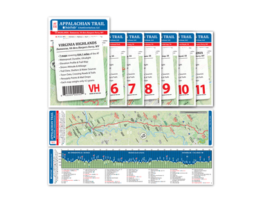
The Pocket Profile Elevation Profile Map is a unique product that combines a guide book with a trail map and an elevation profile in a light weight, water proof, tear resistant tri-fold. The Pocket Profiles are printed on durable water proof tear resistant material. One side contains the full color trail map and the other side features the elevation profile and trail data. Each map is 3.9 in wide and 17 in long and only weighs less than 5 grams! This package contains 5 individual profiles from Damascus Virginia through Harpers Ferry West Virginia
The Pocket Profile Elevation Profile Map is a unique product that combines a guide book with a trail map and an elevation profile in a light weight, water proof, tear resistant tri-fold. The Pocket Profiles are printed on durable water proof tear resistant material. One side contains the full color trail map and the other side features the elevation profile and trail data. Each map is 3.9 in wide and 17 in long and only weighs less than 5 grams! This package contains 5 individual profiles from Damascus Virginia through Harpers Ferry West Virginia
- Waterproof, Durable and Ultralight
- Contains Elevation Profile and Trail Map
- Trail Map Includes: trail data, shelters & water sources, town data, crossing roads & trails, resupply points and mail drops
- Each map weighs only 4.5 grams, the entire set weighs less than 2 oz.
- Each Map is 3.9" x 17"


